Link to interactive US Hardiness Zone Map
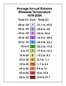
According to Wikipedia, a US hardiness zone map is a geographic area having a certain range of annual minimum temperature. This can affect whether you plants will live or die. The map was developed by the United States Department of Agriculture (USDA) as a rough guide for landscaping and gardening. The temperature is broken down into 13 zones by long-term average annual extreme minimum temperatures.

Find Your Location on the US Hardiness Zone Map
Find your state and city on the map, the color of the map is matched to the temperature zones. The zones are on the right side of the map or above. The numbers within the colored squares indicate your zone. Most gardeners use this as a rough guide because we all know that weather is unpredictable. Also, these temperatures are updated periodically but the images above are from 1976 to 2005. As we all know, climate change is raising temperatures and causing severe weather. However, do not assume that you can move into a more temperate climate zone because of global warming. Your area may still surprise you with a late frost.
How To Extend Your Planting Season
To extend your planting season, you can use cold frames or plant in containers and move the plants into a shed or garage. Another way to protect plants from temperature extremes, both hot and cold, is to add a thick layer of mulch around the base of your plants. Make sure to leave an inch or two around the stem/trunk of the plant. Mulch protects roots from freezing in light frosts and holds in moisture during the dry season. The US Hardiness Zone map is not just for the northern states. You might have extremely hot temperatures. The map can help you plan the best time to plant cold loving plants like lettuce, in hot climates.